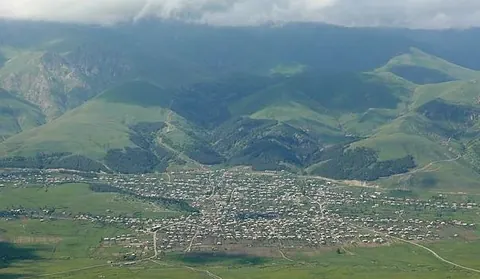
Margahovit, is a major village in the Lori Province of Armenia.
Getting there
107 m above the Aghstev river, which runs 1.7 km away in a straight line.
| From | Road distance | Drive time |
|---|---|---|
| Vanadzor | 20.7 km | 24 min |
| Alaverdi | 63.7 km | 1 h 09 min |
| Stepanavan | 55.5 km | 1 h 03 min |
| Yerevan | 114.2 km | 1 h 50 min |
| Tbilisi | 190.8 km | 3 h 12 min |
Details
- Type
- Village
- Where
- Vanadzor & the Pambak valley
- Elevation
- 1,795 m
- Population
- 3,569
Light
Golden hour is when the sun is less than 6° above the horizon — the warm light for photos. In deep gorges the sun leaves the valley floor earlier.
Photos taken nearby
From Wikimedia Commons, within 1 km. Click a photo for its author and licence.
Weather at Margahovit
Loading the forecast…
Forecast for 1,795 m from Open-Meteo.
Sights nearby
- Viewpoint near FioletovoViewpoint 5.1 km 430 m higher
- Viewpoint near FioletovoViewpoint 5.2 km 338 m higher
- Viewpoint near FioletovoViewpoint 5.3 km 414 m higher
- Viewpoint near FioletovoViewpoint 5.8 km 349 m higher
Nature nearby
- SarisurbPeak 850 m same level
- KhorakanPeak 1.8 km 463 m higher
- IshotsPeak 2.0 km 520 m higher
- TsakutPeak 2.3 km 489 m higher
- Hill ViratsPeak 2.6 km 95 m lower
Stay nearby
- Wolfing MountMountain hut 4.0 km 117 m higher
Services nearby
- Haypost 2037Post office 150 m same level
- Mm MarketConvenience store 200 m same level
- muftBus station 400 m same level
- Fuel in MargahovitFuel 750 m same level
- FioletovoConvenience store 2.9 km 105 m lower
Distances in the "nearby" lists are straight-line; the height difference shows how much climbing a short distance can hide here.